TORONTO, ON / ACCESSWIRE / July 26, 2022 / Signal Gold Inc., ("Signal Gold" or the "Company") is pleased to announce exploration drill results from the Company's Point Rousse operation ("Point Rousse") in the Baie Verte Mining District of Newfoundland (Exhibit A). The diamond drill program included 4,222.0 metres in 29 drill holes testing five main exploration targets (the "Exploration Program"). Drill holes at the Corkscrew and Big Bear targets continue to demonstrate the presence of a strong gold mineralized system within the Goldenville Trend, building on the results announced in March 2022 (Exhibit B). The Company also completed and received data for a total of 90.1-line kilometres of Induced Polarization ("IP") ground geophysical surveys on three (3) grid areas, Corkscrew-Big Bear, Animal Pond and Goldenville, outlining several new targets for follow-up drill testing.
Selected composited highlights from the Exploration Program include:
- 0.91 grams per tonne ("g/t") gold over 17.0 metres (54.0 to 71.0 metres) including 5.18 g/t gold over 1.0 metres in drill hole CS-21-005;
- 1.49 g/t gold over 3.8 metres (134.2 to 138.0 metres) in drill hole BB-22-003;
- 0.81 g/t gold over 4.9 metres (42.4 to 47.3 metres) in drill hole AP-21-011; and
- 4.09 g/t gold over 1.0 metres (52.0 to 53.0 metres) in hole AP-21-010.
"Our exploration programs at Point Rousse continue to identify new areas of exploration potential while also demonstrating the presence of large gold bearing systems, particularly in the Goldenville Trend where we see continued success along the Pumbly Point-Corkscrew-Big Bear corridor. Additionally, the discovery of gabbro-hosted mineralization at Animal Pond is significant in possibly identifying a new gold trend similar to Argyle and Stog'er Tight. The continued discovery of additional gold mineralization and identification of several high-priority targets from an extensive IP survey underscores the potential to delineate additional mineral resources proximal to the Company's operating mill and tailings facility at Point Rousse."
~Kevin Bullock, President and CEO, Signal Gold Inc.
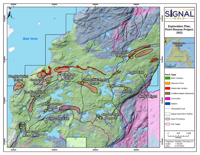
A review of the data generated during the Exploration Program including the recently completed 90.1 line-kilometre IP geophysical survey, as well as previous exploration data, has led to the identification of further high-priority exploration targets at Point Rousse, including the Pumbly Point, Corkscrew-Big Bear, Iron Formation, Animal Pond, Corkscrew Road and Goldenville targets (Exhibit E). Several of the targets (e.g., Iron Formation, Pumbly Point, Corkscrew Road) were previously identified but not fully tested in the winter of 2022 due to early onset of spring conditions. Other targets such as Goldenville and Animal Pond were further outlined from a review of the recently received data from the IP geophysical survey and drill results.
Table 1: Selected composited assays from the Exploration Program
Hole ID | From (m) | To (m) | Length (m) | Gold (g/t) |
| CS-21-005 | 54.0 | 71.0 | 17.0 | 0.91 |
including | 57.0 | 58.0 | 1.0 | 5.18 |
| BB-22-003 | 134.2 | 138.0 | 3.8 | 1.49 |
| BB-22-005 | 110.0 | 111.0 | 1.0 | 0.57 |
| CS-22-006 | 228.9 | 229.7 | 0.8 | 1.60 |
| CS-22-008 | 195.0 | 196.0 | 1.0 | 2.33 |
| AE-21-193 | 60.5 | 61.0 | 0.5 | 0.53 |
| AE-21-194 | 88.3 | 89.3 | 1.0 | 0.53 |
| AP-21-010 | 52.0 | 53.0 | 1.0 | 4.09 |
| AP-21-011 | 13.0 | 14.0 | 1.0 | 0.92 |
and | 42.4 | 47.3 | 4.9 | 0.81 |
| PE-21-005 | 12.7 | 13.3 | 0.6 | 0.55 |
| SA-21-002 | 119.0 | 120.0 | 1.0 | 0.52 |
- Intervals are reported as core length only. True widths are estimated to be between 75% and 100% of the core length.
- All drill hole results are reported using fire assay only. See notes on QAQC procedures at the bottom of this press release.
- Drill holes SA-21-001,003,004; AE-21-195 to -198; CS-22-006 to -008; BB-22-004, 006; GC-22-001; PE-21-001 to -005; and AP-21-007 to -009 did not contain significant gold mineralization.
Exploration Program Details
The Goldenville Trend - Corkscrew and Big Bear
The Goldenville Trend comprises three separate mineralized zones known as Pumbly Point, Corkscrew and Big Bear, which form a zone with a 2.3-kilometre strike length with the potential to host gold mineralization (Exhibit B).
Drilling in nine (9) drill holes totaling 1,955 metres tested IP geophysical targets, as well as follow-up of the encouraging drill results from 2021, at Corkscrew and Big Bear (see news release dated March 31, 2022).
At the Corkscrew Prospect, gold is hosted within a minimum 400 metre long altered, quartz veined and pyrite bearing granodiorite that is between 40 and 100 metres thick. Historic drilling, between 1987 and 2009, was completed over a 325-metre strike extent, which is open in all directions, and intersected several zones of gold mineralization with highlight assays as follows:
- 1.87 g/t gold over 11.5 metres (209.3 to 220.8 metres), including 4.76 g/t gold over 3.0 metres in drill hole M-93-24;
- 8.46 g/t gold over 3.9 metres (228.4 to 232.3 metres) in drill hole M-87-15;
- 3.09 g/t gold over 6.0 metres (65.2 to 71.2 metres) including 19.14 g/t gold over 0.9 metres in drill hole M-87-03; and
- 4.38 g/t gold over 1.2 metres (49.2 to 50.4 metres) in drill hole M-93-21.
Mineralization of 0.91 g/t gold over 17.0 metres encountered in hole CS-21-005 represents a 35-metre northeast extension of the Corkscrew zone, where it remains open along strike and down-dip, representing potential for further expansion (Exhibit B).
The Big Bear Prospect is located 500 metres northeast of Corkscrew and hosted within similarly altered and mineralized granodiorite characterized by quartz veins and disseminated pyrite. Historic chip samples from this zone returned 1.60 g/t gold over 4.0 metres and grabs samples assayed up to 8.23 g/t gold. Broad spaced drilling (40 to 125 metres) in four holes completed in 2009 returned anomalous gold intervals assaying up to 2.28 g/t gold over 1.3 metres (56.5 to 57.8 metres) in diamond drillhole M-09-31.
Drill testing of IP chargeability targets further east and down-dip of the Big Bear Prospect has led to the identification of gold mineralization that continues to support the presence of a large gold bearing alteration system within the host granodiorite. Drill hole BB-22-003 intersected 1.49 g/t gold over 3.8 metres located 60 metres down-dip to the north of the gold zone encountered in previously announced drill hole BB-21-001, which intersected 1.03 g/t gold over 5.4 metres.
Initial drilling in 2021 at Pumbly Point intersected a gold-mineralized structure along a 500-metre trend, which included an intersection of 1.89 g/t gold over 7.8 metres (57.2 to 65.0 metres), including 10.60 g/t gold over 0.8 metres and an intersection of 1.42 g/t gold over 4.0 metres (40.2 to 44.2 metres). The mineralized structure at Pumbly Point is a level of stratigraphy believed to be coincident with the Goldenville Horizon, a prospective geological sequence equivalent to the highly prospective Nugget Pond Horizon located at the Company's Tilt Cove Gold Project. A broader area of prospectivity could be open for further testing should this stratigraphy and structure continue. Drilling did not test the Pumbly Point Prospect in this stage of work and it remains a significant target for follow-up drill testing.
Scrape Trend
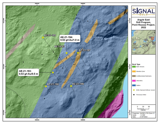
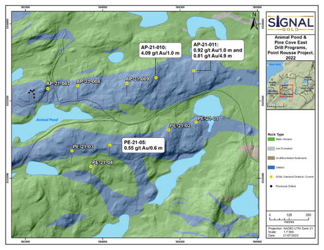
Drilling of four target areas was completed along the Scrape Trend, including the Animal Pond, Corkscrew Road, Pine Cove East and Argyle East targets. Drilling in each area tested a combination of IP chargeability and elevated gold geochemical signatures with five (5) drill holes (AP-21-007 to -010) totaling 581 metres at Animal Pond; four (4) drill holes (SA-21-001 to -004) totalling 481 metres at Corkscrew Road; five (5) drill holes (PE-21-01 to -05) totaling 542 metres at Pine Cove East; and Six (6) drill holes (AE-21-193 to -198) testing the Argyle East target (Exhibits C and D).
Drilling at the Animal Pond target tested several IP chargeability anomalies coincident with and east-west trending gabbro unit, similar to the host at the nearby Stog'er Tight and Argyle mines. Drill hole AP-21-011 intersected gold mineralization assaying 0.81 g/t gold over 4.9 metres (42.4 to 47.3 metres) and drill hole AP-21-010, located 250 metres to the west, intersected 4.09 g/t gold over 1.0 metres (52.0 to 53.0 metres). This zone of mineralization is open along strike to the east, towards Stog'er Tight as well as up- and down-dip (Exhibit C).
Drilling at the Corkscrew Road target tested a large soil geochemical target. While drilling in these four holes only intersected weak gold mineralization in hole SA-21-002, the recent IP geophysical survey shows that the holes did not test the IP chargeability anomaly northeast of the area drilled and follow-up drilling is required to fully assess this new target in light of the new geophysical data set.
Drill testing of IP chargeability targets at the Pine Cove East target intersected near-surface gold mineralization in drill hole PE-21-005 that assayed 0.55 g/t gold over 0.6 metres (12.7 to 13.3 metres; Exhibit C).
At the Argyle East target, drilling was designed to follow-up on high-grade mineralization encountered 1.0 kilometre northeast of the Argyle Mine in previous drill hole AE-18-83 that intersected gabbro-hosted visible gold-bearing quartz veining assaying 6.21 g/t gold over 2.0 metres (96.0 to 98.0 metres; see news release dated March 1, 2019). Follow-up drilling encountered weak zones of gold mineralization assaying 0.53 g/t gold over 0.5 metres (60.5 to 61.0 metres) in drill hole AE-21-193 and 0.53 g/t gold over 1.0 metres (88.3 to 89.3 metres) in drill hole AE-21-194 (Exhibit D).
Qualified Person and Technical Notes
This news release has been reviewed and approved by David A. Copeland, P.Geo., Chief Exploration Geologist with Signal Gold, a "Qualified Person", under National Instrument 43-101 Standard for Disclosure for Mineral Projects.
All samples collected by the Company and the resultant composites referred to in this release were collected using QA/QC protocols including the regular insertion of certified standards and blanks within each sample batch sent for analysis. Diamond drill core samples were analyzed for Au at Eastern Analytical Ltd. in Springdale, NL ("Eastern"), using standard fire assay (30 g) pre-concentration and Atomic Absorption finish methods. Eastern is a fully accredited firm within the meaning of NI 43-101 for provision of this service
A version of this press release will be available in French on Signal Gold's website (www.signalgold.com) in two to three business days.
ABOUT SIGNAL GOLD
Signal Gold is a TSX and OTCQX-listed gold mining, development, and exploration company, focused in the top-tier Canadian mining jurisdictions of Nova Scotia and Newfoundland. The Company is advancing the Goldboro Gold Project in Nova Scotia, a significant growth project subject to a positive Feasibility Study (Please see the ‘NI 43-101 Technical Report and Feasibility Study for the Goldboro Gold Project, Eastern Goldfields District, Nova Scotia' on January 11, 2022 for further details). Signal Gold also operates mining and milling operations in the prolific Baie Verte Mining District of Newfoundland which includes the fully permitted Pine Cove Mill, tailings facility and deep-water port, as well as ~15,000 hectares of highly prospective mineral property, including those adjacent to the past producing, high-grade Nugget Pond Mine at its Tilt Cove Gold Project.
FOR ADDITIONAL INFORMATION CONTACT:
Signal Gold Inc. Kevin Bullock | Reseau ProMarket Inc. Dany Cenac Robert |


SOURCE: Signal Gold Inc.
View source version on accesswire.com:
https://www.accesswire.com/709723/Signal-Gold-Intersects-094-gt-gold-Over-17-metres-and-Identifies-Exploration-Targets-Near-Point-Rousse-in-Newfoundland